2.1.1 More details on slow movements

Slow movements may be distinguished by the following:

Sinking

Sinking is the process of soil consolidation under load. It affects compressible soils (peats, clays, etc). Sinking is a differential process and can cause damage to structures and buildings. Sinking is like a limited progressive subsidence.

Shrinking and swelling

Shrinking is a process caused by the desiccation of the soils due to intense and/or long periods of dryness. Shrinking produces slow, low amplitude, vertical deformations of the ground surface. Shrinking can be followed by progressive swelling processes when soil humidity is increased in the wet seasons. Clayey soils are particularly sensitive to shrinking and swelling because of the specific properties of clay minerals. Shrinking can damage buildings by partial and irregular sinking of the ground.

Progressive subsidence

Progressive subsidence is the process of slow surface deformation with or without fractures due to the evolution of natural or artificial caves (subterranean quarry or mines -iron, salt, coal, etc.-), circular or oval cavities or depressions appeared in surface. Go to 2.1.1.1 More information on progressive subsidence

Slide and Mudslide (or slump-earthflow):

The movement takes place by means of a shear displacement along one or more surfaces or along thin zones of intense shear strain. Either rotational slides (slumps), in which the movement occurs along a curved and concave failure surface, or translational slides, in which the mass moves along a plane or undulating surface, can be found. Go to 2.1.1.2 More information on slide

In some cases, a slide can change into a mudslide or slump-earthflow, especially on steep slopes, in highly tectonized clays or silty formations (Picarelli, 2001; Maquaire et al., 2003). As shown in figure 13, three morphological units can be distinguished: a primary source area with the main scarp and cracks, a track zone thinly covered by a flow (the paleotopography is still clearly discernible), and an accumulation zone, sometimes with several successive lobes. Go to 2.1.1.2 More information on slide>> << Return to More information on different types of landslide

Progressive subsidence scheme (from Maquaire, 2005)

Progressive subsidence is the process of slow surface deformation with or without fractures due to the evolution of natural or artificial caves (subterranean quarry or mines -iron, salt, coal, etc.-), circular or oval cavities or depressions appeared in surface,

What is a progressive subsidence phenomenon?

Subsidence, like sinking, is a very slow process of vertical deformation of large extent. The deformations are triggered by:

  • The natural dissolution of soluble materials (karst phenomena),
  • The extraction of materials (calcareous, etc.) or extraction of ores (iron, salt, coal, etc.).

Subsidence is a phenomenon relatively slow which can last of many years. It generally occurs in ground terrains with flexible behaviour, or in the case of artificial cavities (subterranean quarry or mines), when the depth of exploitation is important compared to the thickness of the size. Subsidence can be the precursor sign of an evolution by rapid subsidence. Subsidence (with vertical component of the movement) results in low depth of vast topographic depressions, generating relative deformations prejudicial to the structures, or, on a large scale, a disorganization of the system of drainage. In limit of these depressions (called sink hole in case of a karst dissolution), zones in extension (with shearing and traction, yielding stresses) can lead to the appearance of cracks.

Scheme of the progressive subsidence process above a subterranean quarry by slow and progressive deformation of the ground terrain with flexible behaviour. With these indications: below, the extension of the subsidence zone, and. above, the extension of the influenced zone (from BRGM, website BDcavité.net, developed by BRGM).

Karstic doline in Vercors due to the dissolution of limestones (Photo: O Maquaire, Cerg)

References:
COTE, PH., FAUCHARD, C., POTHERAT, P. (2005). Méthodes géophysiques pour la localisation de cavités souterraines : potentialités et limites. In Evaluation et gestion es risques liés aux carrières souterraines abandonnées. Actes des journées scientifiques du LCPC, pp. 8-17.

EMBLETON, C., AND EMBLETON C. (EDS.) (1997), Geomorphological Hazards of Europe. Developments in Earth Surface Processes 5. Amsterdam : Elsevier, 524p.

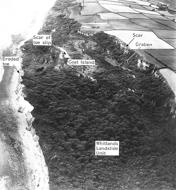
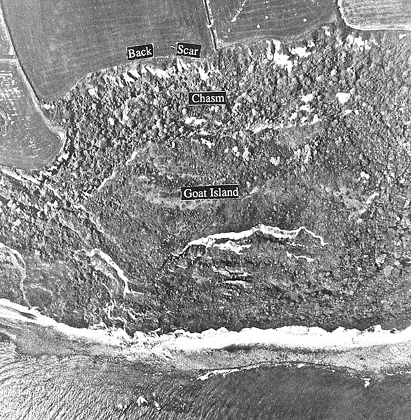
FLAGEOLLET, J. C. (1988), Les mouvements de terrain et leur prévention, Paris : Masson, 224p. LCPC (2000). Guide technique pour la caractérisation et cartographie de l’aléa dû aux mouvements de terrain. Collection ‘les risques naturels’. Laboratoire Central des Ponts et Chaussées, 91 p.

MAQUAIRE, O., (2005). Geomorphic hazards and natural risks, In: Koster, E., A. (ed.), The Physical Geography of Western Europe, Oxford Regional Environments, Oxford University Press, Chapter 18, 354-377.

MINISTERE DE L’ENVIRONNEMENT, (1997), Plans de prévention des risques naturels (PPR) : guide général.. La Documentation Française, Paris, 76p.

MINISTERE DE L’ENVIRONNEMENT, (1999), Plans de prévention des risques naturels (PPR) : risques de mouvements de terrain. Guide méthodologique.. La Documentation Française, Paris, 71p.

MINISTERE DE L’ECOLOGIE ET DU DEVELOPPEMENT DURABLE, (2004). Dossier d’information sur le risque Mouvement de terrains, 20 p. (à télécharger sur site du MEDD).

POTHERAT, P. (2005). L’opération de recherche « Carrières souterraines abandonnées ». Localisation, diagnostic de stabilité, gestion. Rapport de synthèse. Géotechnique et risques naturels, GT 77. LCPC, 132 p.

Extract from Maquaire and Malet, 2006)

A slide is a mass movement of material throughout the length of a ‘rupture’ or ‘sliding’ surface. Slide could be rotational (the sliding surface is curved) or translational (the sliding surface is more or less straight). It depends on the materials but also on the shape and length of the slope. The 1:10 ratio between depth and length is a criterion for the classification of a landslide rotational or translational. Many slides are composite and the movement takes place over the length of a sliding surface which is concave upstream and flat downstream. Many slides also occur over an irregular surface (Flageollet, 1988), and they vary considerably because of the nature and size of the materials (fragments of coherent rock, loose rock, soil) and the velocity.

Rotational slides

A single rotational slide is a ‘more or less rotational movement, about an axis that is parallel to the slope contours, involving shear displacement (sliding) along a concavely upward-curving failure surface, which is visible or may reasonably be inferred’ (Varnes, 1978). The morphology of the rotational slide is typical (Figure): upstream a main scarp with a steep slope, which is the visible part of the sliding surface, and tilted blocks (counterslopes) curtailed by scars along which slide striations are sometimes visible.

Figure 1: Typical block diagram of a rotational slide (from Dikau et al., 1996)

Figure 2: Typical block diagram of a rotational slide (from Dikau et al., 1996)
Figure 3: Oblique aerial photographs of the main scarp and multiple rotational landslides on the sea cliff at Stonebarrow Hill, Dorset, UK (from Dikau et al., 1996) 

They may be single, multiple, with several movements of the same type close to each other, or successive, i.e. interlocking (Figure). Rotational slides can vary from terracettes with an area of only a few square meters (in this case, they are considered as shallow landslides) to large slides of several hectares. 

Figure 4: Rotational earth slide in clay formation in the Panaro River valley, Northern Apennines, Italy (photos by D. Castaldini)

Translational slides

Figure 5: Schematic block diagram of a typical translational slide (from Dikau et al. 1996)

In translational slides, the material displaces along a planar or undulating surface of rupture, sliding out over the original ground surface. Translational slides often follow discontinuities more or less parallel to the slope, and are often superficial (such as contact between the rock and residual soils). Deeper, they occur along structural faults, joints, or bedding planes.

Figure 6: Cross-section and aerial view at Le Bouffay, northen France, displaying the translational horizontal slide and the subsequent collapse (from Maquaire, 1990)

Translational slides on single discontinuities in rock masses have been called rock block slides (Figure 7g) or planar slides (Cruden and Varnes, 1996). Sometimes the surface of rupture may be formed by two discontinuities that cause the contained rock mass to displace down the line of intersection of the discontinuities, forming a wedge slide (Figure 7h). A stepped slide may result if two or more sets of discontinuities, such as bedding surfaces and some joint sets, penetrate the rock masses (Figure 7i).This type of slide is usually very rapid. Smooth discontinuities or thin clay levels may act as a lubricant; infiltration water reduces friction, triggers excess pore pressures and provokes the sliding of one rigid block on another.

Figure 7: Different types of rock block slide (from Maquaire and Malet, 2006, adapted from Cruden and Varnes, 1996; Dikau et al., 1996)
Figure 8: Debris slide (from Maquaire and Malet, 2006, adapted from Cruden and Varnes, 1996; Dikau et al., 1996)

Translational slides can occur along soil-bedrock discontinuities or permeable/impermeable soil junctions in slopes formed by coherent, fine soils or coarser debris. In this case, translational slides are termed soil slides, debris slides (Figure j) or slab slides. Debris slides and slab slides are normally shallow according to their length and width. Their velocities are linked to seasonal variations in groundwater levels and in the saturated conditions.

Figure 9: Oblique (on the left) and vertical (on the right) aerial photograph of the Bindon translational slide Devon, UK (from Dikau et al. 1996)

Figure 10: Translational earth slide in predominantly fine material at Deva County, Romania (photos by D. Castaldini)

Figure 11: Translational rock slides occurred in November 1994 in Piemonte Apennines, Italy (Photos Archivio CNR IRPI, Torino)

Figure 12: Panoramic views of the body and of the rock-slide surface of the Vajont landslide (from Dikau et al. 1996) Mudslide (or slump-earthflow)
Figure 13: Mudslide (from Maquaire and Malet, 2006, adapted from Cruden and Varnes, 1996; Dikau et al., 1996)

In some cases, a slide can change into a mudslide or slump-earthflow, especially on steep slopes, in highly tectonized clays or silty formations (Picarelli, 2001; Maquaire et al., 2003). As shown in figure 13, three morphological units can be distinguished: a primary source area with the main scarp and cracks, a track zone thinly covered by a flow (the paleotopography is still clearly discernible), and an accumulation zone, sometimes with several successive lobes.

Figure 14: Mudslide triggered near the town of Corps in the Spring of 2001 (Trièves, South Alps, France, May 2001).

Figure 15: Lobate earthflow, 1969, Black Ven, Dorset, UK (from Dikau et al., 1996)
Figure 16: Earthflow near Cortina d’Ampezzo, Dolomites, E Alps, Italy (from Dikau et al., 1996)

Figure 17: Boschi di Valoria earth flow, northern Apennines, Italy in 1996 (on the left) and in 2001 after its reactivation (on the rigth) (photos by A. Corsini)

Figure 18: Super-Sauze earth flow, Alps, France (photo by M. Soldati) (see Case Study Super-Sauze)

References:

For the references herein and for knowing sources of didactic material go to 1.3 Selected references.