Pericolosità Naturali
Alluvioni
Preparato da ECRP – European Center for Risk Prevention (Sofia, Bulgaria) & the Editorial Board.

Un’alluvione è determinata dal temporaneo ricoprimento, da parte dell’acqua, di una superficie di terreno generalmente libera da acqua.
Alluvioni possono essere causate da corsi d’acqua (fiumi, sorgenti di montagna, corsi d’acqua solitamente asciutti ecc.), che non sono in grado di contenere afflussi d’acqua eccessivi.
Gran parte di tali afflussi deriva da precipitazioni intense o prolungate, ma altre cause (tra cui intenso scioglimento di ghiaccio/ghiacciai, maree costiere, sovralzi di tempesta o maremoti) possono a loro volta causare alluvioni. Non viene considerato come alluvione l’esondazione d’acqua derivante dall’inefficienza delle reti fognarie.
Le alluvioni sono una potenziale causa di incidenti, di esodi di popolazioni, capaci di danneggiare l’ambiente e di compromettere in modo grave lo sviluppo economico.
Un’alluvione si verifica quando l’acqua va ad occupare una porzione di terreno che solitamente ne è priva. Le alluvioni possono verificarsi ad opera di fiumi, corsi d’acqua montani od effimeri delle regioni mediterranee e del mare, intenso scioglimento di ghiaccio/ghiacciai o effetti derivanti dalla rottura o dall’inofficiosità del sistema fognario. A originare un’alluvione sono prevalentemente piogge abbondanti o prolungate. Le precipitazioni, infatti, possono avere effetti significativi sulla portata di fiumi, torrenti e canali. Un corso d’acqua può ingrossarsi fino a esondare, cioè straripare o rompere gli argini, allagando il territorio circostante. Non tutti i corsi d’acqua, però, si presentano e si comportano allo stesso modo. I torrenti diventano veri e propri fiumi solo quando piove molto. Al diminuire delle precipitazioni, il livello delle acque può ridursi fino a lasciare il letto asciutto.
Le alluvioni sono potenziale causa di incidenti e possono costringere le persone ad abbandonare per un certo periodo le loro abitazioni, determinando danni all’ambiente ed al tessuto socio-economico. In generale, le alluvioni hanno effetti più gravi nei centri urbani
Sebbene le alluvioni siano innescate da fenomeni naturali che non possono essere impediti, le loro conseguenze negative possono essere ridotte
Per “rischio alluvionale” si intende la combinazione tra la probabilità che si verifichi un’alluvione e le potenziali conseguenze negative che questa può determinare sulla salute umana, sull’ambiente, sul patrimonio culturale e sulle attività economiche.

A seconda delle cause che le determinano, le alluvioni si possono generalmente suddividere in tre gruppi:
- Primo gruppo – alluvioni causate da piogge intense o prolungate o dalla rapida fusione di neve, ghiaccio/ghiacciai;
- Secondo gruppo – alluvioni causate da forti venti. Si possono verificare lungo la costa ed in corrispondenza dello sbocco dei fiumi in mare;
- Terzo gruppo – alluvioni causate da terremoti sottomarini e, meno frequentemente, da eruzioni di vulcani sottomarini od insulari. I terremoti e le eruzioni sottomarine possono causare onde giganti – maremoti, che solitamente producono alluvioni nella fascia costiera .
Si possono ulteriormente distinguere attraverso le seguenti tipologie:
- Alluvioni fluviali
Avvengono in prossimità degli alvei fluviali. Sono le più frequenti e ne esistono di diverse tipologie. (vai a 2.1) - Alluvioni legate al drenaggio locale od all’innalzamento dei livelli di falda
In questa tipologia rientrano le alluvioni causate dall’inofficiosità del drenaggio locale e quelle causate dall’innalzamento dei livelli di falda che si sviluppano in aree urbane (Fig.2). Questa tipologia di alluvioni è principalmente causata dalla cattiva manutenzione, dalla mancanza di controllo o dalla pessima condizione dei sistemi idraulici in aree urbane. Queste alluvioni determinano il peggioramento delle normali condizioni di vita ed è causa di perdite economiche. Oltre che in corrispondenza delle piane alluvionali e dei principali assi di drenaggio, precipitazioni locali molto intense possono generare alluvioni anche in aree diverse. Se le condizioni locali non sono sufficienti a sostenere le intense precipitazioni, grazie all’infiltrazione ed al deflusso superficiale, le acque possono accumularsi e determinare un’alluvione. Anche l’innalzamento dei livelli di falda può essere fonte di preoccupazione e può produrre effetti negativi anche in assenza di eventi alluvionali. I piani interrati delle case sono particolarmente suscettibili agli alti livelli della falda. - Alluvioni legate all’oscillazione dei livelli dei laghi
Questa tipologia di alluvioni interessa, solitamente, ampie aree pianeggianti in prossimità delle coste lacustri ed ha una persistenza prolungata nel tempo. I cambiamenti climatici influiscono sulla frequenza e sull’estensione di questa tipologia di alluvioni, poiché il ciclo idrologico viene interrotto. Il livello dei laghi può avere fluttuazioni di breve termine, stagionali, o di lungo termine, di mesi od anni. Precipitazioni intense, stagionali, possono determinare l’innalzamento del livello dei laghi in brevissimo tempo, mentre la fusione del manto nevoso può incrementare il deflusso dalle sorgenti. Le fluttuazioni di lungo termine sono un fenomeno meno conosciuto, ma che può determinare alti livelli d’acqua e relativi problemi di alluvionamento che possono permanere per anni o addirittura per decenni. - Alluvioni (Inondazioni) costiere
Le alluvioni costiere, in combinazione con altre tipologie di alluvioni (in particolare quelle fluviali), possono produrre enormi perdite. (vai a 2.2)
Il termine ‘’alluvione devastante” viene usato per indicare tutte le tipologie sopra indicate, in grado di produrre enormi perdite in vite umane ed economiche.
Riverine flooding includes:
– Overflow from river channel or river floods
This kind of floods are with highest frequency. They are caused by bank overtopping when the flow capacity of rivers is exceeded locally. (Fig. 2.1 a)
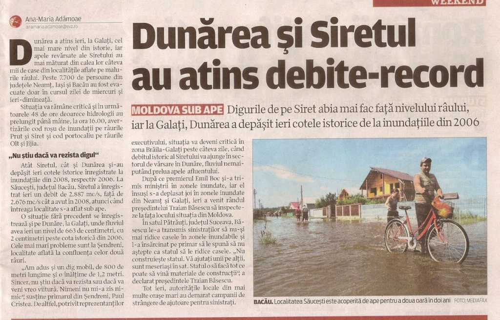
The activity of the local authorities for the prevention of flood risk is most important to reduce the consequences.
The general factors affecting the river floods are the intensity and the duration of the rainfall, the possibility of rivers and steams to let pass the rising waters, the condition of the land surface – soil and vegetation, topography, etc. The river floods occur at the higher scale of the rainfall system, where the permeability capabilities of the multitude of smaller tributaries are gradually filled up and the water peak is usually gradually collected and transported to the larger river.
The lengthy rivers flow through flat terrain and the water movement speed is low. The same applies in the occurrence of a flood; the water peak is reached very slowly and afterwards it fades down very slowly over the course of a few days to a few weeks. Usually the reason for the flood is intensive and prolonged rainfalls occurring in other regions, often in other countries within the fluvial catchment area. The situation becomes even more complex when the heavy rainfall continues along the river. These floods are predictable as they are usually of seasonal character and this allows for the proper organization of actions aiming to decrease the consequences.
– Flash floods
There are floods caused by heavy rainfall taking place within a short timeline.
During the last decade, the frequency of these kinds of floods has increased with climate change.
Such floods are harder to predict and they can occur in dry places where there is no running river. Such floods can prove to be very dangerous since they start suddenly and develop very rapidly.
In the case of flash floods, the reaction is mostly hindered by the very short time between their origination/continuous heavy rainfall/ and the reaching of the water peak in a short time.
The flash flood is characterized by the rapid increase in the water level, the high speed and large quantity of debris in water, giving the flood a high destructive power. The main factors causing the origination of a flash flood are the intensive and continuous rainfall and the steep water sheds.
In certain regions the flash floods often result from isolated high-speed local rainfalls, rendering the warning and protection of the population a very difficult task. In other regions such floods occur annually in one and the same river, where warning the population is possible, but advance organization is needed, since the reaction time is quite short. Flash floods are capable of tearing out trees, undermining buildings and bridges and scouping new chanels.
During the month of April 2020, Yemen has experienced heavy rains which caused flash floods in different areas of the country. At least 150,000 people were affected and according to the health authorities seven people died. More recently, on 5th august 2020, at least 17 people, including 8 children, have been killed in flash floods in Yemen’s northern region.
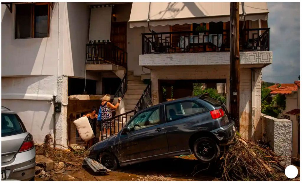
On 9th august 2020, heavy rains and thunderstorms have caused flash flooding on the on Greek Island of Evia, killing at least seven people including a baby (See Fig. 2.1 b). The news was posted on 10th august 2020 also in the https://www.facebook.com/BeSafeNet.

– Alluvial fan floods
This type of flooding is typical for mountain and volcanic areas and rare for other regions.
Alluvial fan floods which adversely affect people lives usually occur when the threatened areas are at the passage between the mountain and flat areas or mountain and seacoast. When the requirements for the building works are not respected, there is a lack of control and the prevention plans are a formality. The consequences are always very destructive and with many victims e.g., in Venezuela in 1999, 19 000 people died.
The common torrents pass through the main riverbed and most of them have a stone-muddy structure. They are particularly dangerous since they often pass through urbanized areas (Fig.2.1 c). Their most dangerous characteristics are the suddenness, the straightforwardness of movement and the transportation of large quantities of hard materials, which pile up on, or destroy along their way settlements, roads, railway tracks, engineering equipment and agricultural lands.
The destructive forces of the torrent are defined by the increased capability to transport hard materials, the interruptibility of the movement, the high velocity of up to 15km per hour.
The human activity, related to the intensive use of mountain slopes leads to the increase in the volume and frequency of this type of flood, as well as to the increase in the number of locations where they can occur.
Alluvial fan floods. Their name/fan/ corresponds to the shape of the spreading mass. In substance they are the same as the above described but the solid mass prevails and they are more similar to the landslide.
Alluvial fan floods can cause greater damage than typical riverine flooding.
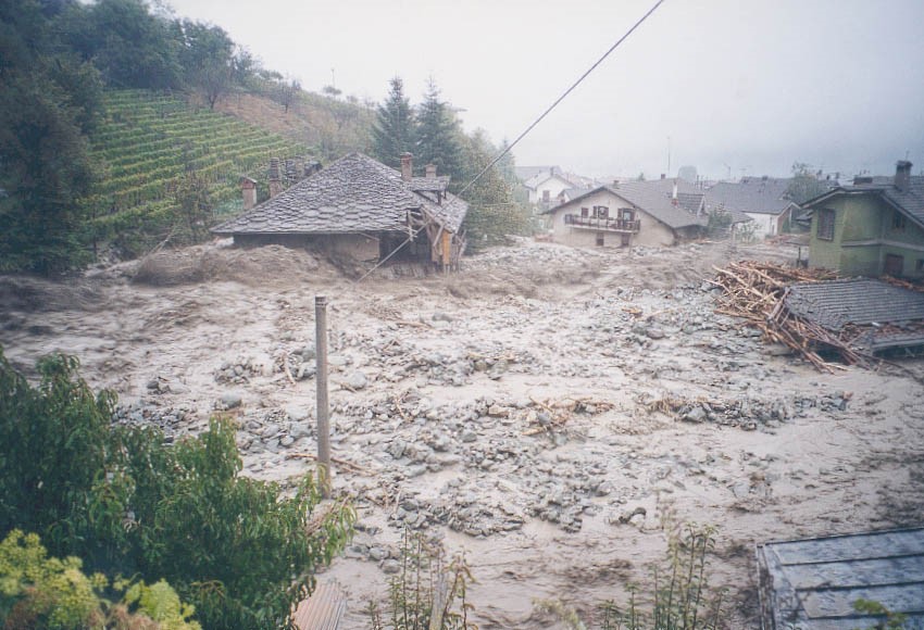
– Ice-jam floods
Floods caused by fast melting of ice/glacier. This kind of flooding in most cases can be predicted and this allows for organizing and undertaking measures for lowering of the consequences.
Serious damage is caused by river floods owing to the combination between rising waters and ice movement. The ice movement is usually accompanied with jamming/filling up of the riverbed with ice or by the accumulation of intra-water ice, forming an icy barrier, which in turn causes an additional increase in the water level and the flooding of new territory upstream. Furthermore, in case of breach of the ice barrier a powerful wave is created that could suddenly flood the territories located downstream.
The jamming of the river by ice occurs most often in rivers flowing from south to north such as the Oder, Wisla, Ob, Yenisei, Lena, Yukon and others.
This is explained by the fact that the southern parts of the river free themselves earlier than the northern sections, in the course of which the moving water, mixed with ice, meets an obstacle of fully frozen sections. Ice barriers can also be created at the beginning of the winter prior to the complete freeze, when there are still sections of the river that are not frozen yet. Sometimes this type of flood can occur in lengthy rivers flowing from west to east e.g., the Danube, and Amur.
The origination of such floods depends on the climate and the physical condition of the river valleys. The freeze is lesser where the waterside is higher and steeper. The freeze is usually more severe in dams, in engineering equipment, at the turns and bridges and at places where the river has low depth over a long distance.
For such type of floods, the estimated reaction time is rather short, requiring an obligatory and serious advance preparation. Since the locations of the ice jams will be known in advance thanks to long years of experience, precaution measures can be taken long time before the start of the ice movement in the river.
The elimination of the ice barriers is done through detonations or by using an ice-breaker, if possible.
– Dam-break floods
They happen very rarely but cause a high number of casualties. The permanent control of the hydro technical installations and organization of the announcement and protection of the threatened population are of great importance.
It is worth noting that the big flooding that occurred during the last two decades in most cases are the result of a combination of different kinds of floods, usually among the river flood and other kinds of flood as: provoked by a string wind, intensive and long lasting rainfalls, Monsoon, sea inflows, increase of the level of the underground waters or destruction of the functions of the drainage channels and other.
The breaking of a dam wall, especially of large dams, is rather rare and can hardly be foreseen. The overflow of water from medium- and small-seized dams is an event occurring more often as well as the breaking of the of land type walls of the small dams.
The floods caused by break of walls of large dams can be very dangerous since they can affect the life of a lot of people.
The breaking of a dam wall can occur in the case of a breach in the construction as a result of progressive erosion in the wall, destruction of the embankments /dikes. A construction breach can also occur in the event of a particularly severe flood. The dam walls are designed to withstand a powerful earthquake, but even so, an earthquake can extremely weaken the wall.
The floods caused by a dam wall break, due to their unexpectedness and high water speed, can inflict casualties and destruction comparable only to a natural disaster. This is the reason why the large dam walls are placed under constant control and surveillance with special equipment installed inside the wall, monitoring for any deviation in the facility’s parameters. Furthermore, the dam walls have inbuilt automated systems for warning the population about danger.
These are cases of floods at the riverbed after the dam wall which is not broken. Such a flood happened in Italy in 1963 when a huge landslide into Vaiont Dam pushed out the dam water which spilled over the dam wall without breaking it but causing catastrophic flooding in which 3000 people died.
The local authorities obligatorily have to include all dams in the protection plans.
In most cases, the smaller dams used for watering and other activities cause major problems. Usually their walls are of land type and require permanent maintenance and control of installations. When such walls are poorly maintained, they become very dangerous during intensive rainfalls or intensive snow melt. The local authorities have to keep records of such dams, to control permanently and to make organization for risk prevention.
For more information please click
http://www.besafenet.net/en-gb/technological-hazards-dam-failures#faq199
Of all river floods this is the one that is the most frequent.
The general factors affecting the river floods are: the intensity and the duration of the rainfall, the possibility of rivers and steams to let pass the rising waters, the condition of the land surface – soil and vegetation, topography and others. The river floods occur at the higher scale of rainfall system, where the permeability capabilities of the multitude of smaller tributaries are gradually filled up and the water peak is usually gradually collected and transported to the larger river.
These floods can be divided into two groups, depending on the form of the water-collection area and the length of the river:
- The first group includes floods occurring in lengthy rivers /Nile, Danube, Euphrates, Mississippi, Rhine, and others.
- The second group includes floods occurring in rivers with round shape of the water-collection basin /Congo/.
The lengthy rivers flow through flat terrain and the water movement speed is low. The same applies for the occurrence of a flood, the water peak is reached very slowly and afterwards it fades down very slowly over the course of few days to few weeks. Usually the reason for the flood is intensive and prolonged rainfalls occurring in other regions, often in other countries. The situation becomes even more complex when the heavy rainfall continues along the river. These floods can be predicted, they are usually of seasonal character and this allows establishing a proper organization to decrease the consequences.
In the case of rivers with round water-collection basin, after heavy rainfall the water peak reaches its highest value quickly and quickly decreases. Such floods usually happen in small and average sized rivers. Usually they are much more destructive because the water moves with higher speed.
The above examples refer to smaller rivers with similar characteristics.
Flash floods are often associated with isolated and localised intense rainfall. But Flash floods may result from the failure of a dam or the sudden breack-up of ice jam. Flash floods in urban areas is serios problem too.
The change in the climate has increased the floods of this type. Such floods are harder to predict, they can occur in dry places where there is no running river. Such floods can prove very dangerous since they start suddenly and develop very fast.
In the case of flash floods the reaction is mostly hindered by the very short time between their origination /continuous heavy rainfall/ and the reaching of the water peak in short time.
The flash flood is characterized by the fast increase in the water level, the high speed and large quantity of debris in water, giving the flood a high destructive power. The main factors causing the origination of a flash flood are: the intensive and continuous rainfall and the steep water sheds.
In certain regions the flash floods often result from isolated high-speed local rainfalls, rendering the warning and protection of the population a very difficult task. In other regions such floods occur annually in one and the same river, where warning the population is possible, but advance organization is needed, since the reaction time is quite short. Flash floods are capable of tearing out trees, undermining buildings and bridges and scouping new chanels.
Mountain torrents occur at intensive rains for long and short time in the mountain areas. This happens because the river bed slop is big, the water runs fast and carry with itself dispersive mass.
The improvement of the forecast systems already gives opportunity for announcement and information of the population at the threatened zones in most cases.
The above mentioned floods appear mostly at the rivers or dry river valleys they are included in the group of the river flooding.
Alluvial fan floods is a temporary spring formed in the beds of the mountain rivers, characterized in the sharp increase in the water level, which has a high content /10 to 75%/ hard particles /soil products and rock decomposition products /.
This kind of flood originate as a result of intensive and continuous heavy rainfall, swift melting of the seasonal winter cover or of glaciers, as well as due to the landslide of loose, cracked rock material /at terrain inclination of no less than 8 – 10%/.
Depending on the content of the torrent mass we can specify the following torrents: stone-muddy, water-stone and water-gravel. Besides that as a physical phenomenon they can be free or latent. The transporting medium of the free torrents is water with hard admixtures /Mud-steam/, and for the latent ones the medium is the soil mixture where the main water mass is connected with finely dispersed particles (Mud-flow, Debris flow) Mud-rock flow and Alluvial fan floods – the contents of the mass is mostly soil and rocks/stone –mud/.
In contrast to the regular flows, flows of the mass by default do not move permanently, but in separate waves /pushes/. The volume of the one-time mixture, transported with high velocity, may vary from hundreds of thousands to millions of cubic liters. The front of the moving mixture can have a diameter of 3-4 meters, and mass of 100 – 200 tons. With their large mass and movement speed this mass destroy roads, equipment, agricultural land and others.
The causes for the origination of this kind of flood are mainly the heavy rainfall, the accumulation of masses of crumbly and cracked material, the increase of the intensity of the surface water outflow.
The practice has demonstrated that the centre of this kind of flood/accumulated soil and rock masses/ starts to move after overcoming the resistance of the terrain and other obstacles, that are destroyed by the rain waters, and the rock and soil mass finds a way under the form of separate flows, which join the main flow, moving with high velocity.
This kind of flood within the river basin can be local or common. The local torrents originate in the beds of the river tributaries or in separate gullies.
The common torrents pass through the main river bed and most of them have stone-muddy structure. They are particularly dangerous since they often pass through urbanized regions. Their most dangerous characteristics are the suddenness, the straightforwardness of movement and the transportation of large quantities of hard materials, which pile up on, or destroy along their way settlements, roads, railway tracks, engineering equipment and agricultural lands.
The destructive forces of the torrent are defined by the increased capability to transport hard materials, the interruptibility of the movement, the high velocity of up to 15km per hour.
The human activity, related to the intensive use of mountain slopes leads to the increase in the volume and frequency of this type of floods, as well as to the increase in the number of locations they can occur.
Alluvial fan floods. Their name/fan/ corresponds to the shape of the spread mass. In substance they are the same as the above described but the solid mass prevails and they are more similar to the landslide.
Alluvial fan floods can cause greater damage than typical riverine flooding.
Volcanic ashes and Mudflows. They arise as a result of the Pyroclastic flow – this is a flow of heat gasses over the volcano slopes /about 1 000 C/ which quickly melt the snow into worm water running with high speed over the steep volcano slopes and carrying with itself solid materials. This phenomena is extremely dangerous for the people living near by.
For more information please click HERE
Floods caused by swift melting of ice/glacier.
Serious damages are caused by river floods caused by the combination between rising waters and ice movement. The ice movement is usually accompanied with jamming/fill up of the river bed with ice / or by the accumulation of intra-water ice, forming an icy barrier, which in turn causes an additional increase in the water level and the flooding of new territory upstream. Furthermore, in case of breach of the ice barrier a powerful wave is created that could flood the suddenly flood territories located downstream.
The jamming /barring/ of the river by ice occurs most often in rivers flowing from south to north /Oder, Wisla, Ob, Yenisei, Lena, Yukon and others/.
This is explained with the fact that the southern parts of the river free themselves earlier than the northern sections, in the course of which the moving water, mixed with ice, meets an obstacle of fully frozen sections. Ice barriers can also be created at the beginning of the winter prior to the complete freeze, when there are still sections of the river that are not frozen yet. Sometimes this type of flood can occur in lengthy rivers flowing from west to east /Danube, Amur/.
The origination of such floods depends on the climate and the physical condition of the river valleys. The freeze is lesser where the waterside is higher and steeper. The freeze is usually more severe in dams, in engineering equipment, at the turns and bridges, at places where the river has low depth over a long distance.
For such type of floods the estimated reaction time is rather short, requiring an obligatory and serious advance preparation. Since the locations of the ice jams will be known in advance thanks to long years of experience, precaution measures can be taken long time before the start of the ice movement in the river.
The elimination of the ice barriers is done through detonations or by using an ice-breaker, if possible.
The breaking of a dam wall, especially of large dams, is rather rare and can hardly be foreseen. The overflow of water from medium- and small-seized dams is an event occurring more often as well as the breaking of the of land type walls of the small dams.
The floods caused by break of walls of large dams can be very dangerous since they can affect the life of a lot of people.
The breaking of a dam wall can occur in case of breach in the construction as a result of progressive erosion in the wall, destruction of the embankments /dikes/. A construction breach can also occur in the case of a particularly severe flood. The dam walls are designed to withstand a powerful earthquake, but even so the earthquake can extremely weaken the wall.
The floods caused by dam wall-break, due to their unexpectedness and high water speed, can inflict casualties and destruction comparable only to a natural disaster. This is the reason why the large dam walls are placed under constant control and surveillance with special equipment installed inside the wall, monitoring for any deviation in the facility’s parameters. Furthermore, the dam walls have automated systems for warning the population of danger.
These are cases of flood at the river bed after the dam wall which is not broken. Such a flood happened in Italy in 1963 when a huge landslide into Vaiont Dam pushed out the dam water which spilled over the dam wall without breaking it but causing catastrophic flooding / 3000 people died/.
The local authorities obligatorily have to include all dams in the protection plans.
In most cases the smaller dams used for watering and other activities cause big problems. Usually their walls are of land type and require permanent maintenance and control of installation. When such walls are maintained badly they become very dangerous at intensive rainfalls or intensive snow melt. The local authorities have to keep records of such dams, to control permanently and to make organization for risk prevention.
For more information please click HERE
The following are the most important types of coastal floods:
– Storm Surge Floods
Often the hurricanes or the storm are in the sea. As a result, large waves are formed battering the coast and causing floods.
Storm surges commonly occur with coastal storms caused by massive low-pressure systems with cyclonic flows that are typical of tropical cyclones and severe winterstorms.
Factors influencing Storm surge intensity are: wind velosity, storm surge height, coastal shape, nature of coast and human activity.
Storm surges are controlled by four factors:
– The more intense storms have higher wind speeds which drive greater amounts of water across the shallow continental shelf, thereby increasing the volume and elevation of water pushed up against the coast. In areas with mild slopes and shallow depths, the resulting flooding can reach great heights.
– The low barometric pressure experienced during coastal storms can cause the water surface to rise, increasing the height of storm surges.
– Storms landfalling during peak astronomical tides have higher surge heights.
– Coastal shoreline configurations with concave features or narrowing bays create a resonance within the area as a result of the winds forcing in water, elevating the surface of the water higher than experienced along adjacent areas of open coast.
For more information please click
http://www.besafenet.net/en-gb/natural-hazards-hurricanes-and-storms-surges#faq315
– Estuarine floods
They are floods caused by the combination of strong winds and high tide.
This type of floods is typical for the Tropical and Equatorial belts and especially for islands e.g. Filipinas. With the change in climate they start manifesting themselves with increased intensity. Such floods in combination with other kind of floods like river ones can affect large areas within a short space of time.
– Floods caused by powerful pressing wind at the mouth of rivers, as a result of which water is retained in the river and the river water level rises.
– Floods resulting from tsunamis which are large seismic sea waves, impulsively generated by shallow – focus or high magnitude earthquakes which can cause disastrous flloding in coastal areas (Fig.2.2 a).
For more information please follow the link.
http://www.besafenet.net/en-gb/natural-hazards-tsunami#faq105)
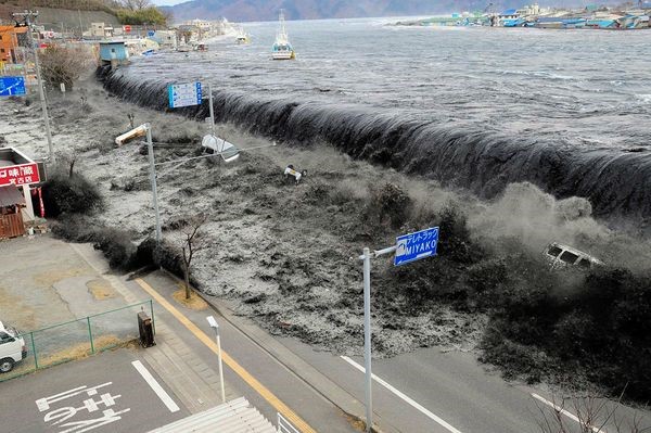
Given that Coastal floods happen continuously in one and same region for most cases, they can be predicted precisely.
Usually the coastal floods are a combination of some of the above-mentioned floods including the river floods.
It is obligatory to elaborate and implement proper national and regional policies as well as national and regional plans to reduce the losses caused by floods.
Le ragioni principali sono l’innalzamento del livello dell’acqua oltre il normale livello o l’interruzione del normale flusso delle acque. Decisivi, per l’ordine di grandezza degli effetti, sono la velocità di flusso dell’acqua ed il tempo impiegato da questa per raggiungere un determinato oggetto.
Le cause che portano il livello delle acque ad oltrepassare il livello normale sono le seguenti:
- Precipitazioni intense o prolungate o rapida fusione di neve o di ghiaccio (dai ghiacciai)
- possono causare alluvioni lungo i corsi d’acqua, nelle basse pianure, possono cambiare i livelli d’acqua dei laghi ecc.;
- Venti forti
- sono la causa delle alluvioni costiere e di quelle in corrispondenza dei delta fluviali; sono particolarmente pericolosi quando si combinano con le alte maree (come avviene nelle Filippine). Causa dei forti venti sono le tempeste marine, gli uragani, i monsoni ecc.;
- Ostruzione dell’alveo fluviale
- a causa dell’eccesso di vegetazione in alveo, dello sbarramento del fiume da parte di masse di ghiaccio, di frane ecc.;
- Distruzione o malfunzionamento di strutture idrauliche
- dighe, argini, tubi drenanti ecc.;
- Rotture arginali per: erosione, alterazioni prodotte dalla fauna selvatica, alterazioni prodotte dalla vegetazione selvatica,
- Terremoti sottomarini (vulcani sottomarini od insulari)
- danno origine ad onde di maremoto (tsunami) che rappresentano la principale causa di alluvioni catastrofiche;
- I cambiamenti climatici
- rappresentano una causa dell’incremento dell’intensità e delle conseguenze negative delle alluvioni; favoriscono la combinazione di più cause responsabili delle alluvioni, amplificando i danni conseguenti;
- Le azioni antropiche
- possono rappresentare un fattore di amplificazione dei danni da alluvione. La deforestazione, la modifica del corso dei fiumi (es. tagli di meandri) che causano dinamiche idrauliche più intense, la costruzione di opere in aree soggette ad alluvioni, la cattiva manutenzione delle installazioni idrauliche contribuiscono ad amplificare gli effetti delle alluvioni. Cambiamento dell’uso del suolo (comprese le questioni urbane, industriali, agricole, forestali e della fauna selvatica).
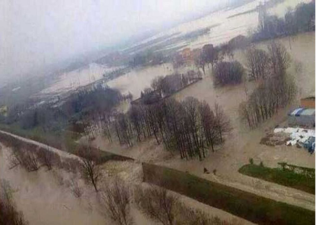
Solitamente le alluvioni avvengono lungo il corso dei fiumi, lungo le coste, in prossimità di laghi e dighe. Alluvioni improvvise possono avere luogo praticamente ovunque.
Nel mondo:
Le alluvioni possono avere luogo ovunque nel mondo. Solitamente si mantiene traccia di quelle alluvioni che hanno minacciato la vita di molte persone. Ad esempio, le grandi alluvioni lungo i fiumi dell’Asia settentrionale e dell’America settentrionale/Alaska, che interessano vasti territori, ma che non producono perdite in termini di vite umane, vengono solo riportati a titolo di informazione.
Alla fine del XX secolo, le alluvioni più grandi, che hanno causato la perdita di molte vite umane, hanno solitamente interessato i paesi delle fasce tropicale ed equatoriale, nelle valli dei grandi fiumi, od i paesi che si affacciano sulle coste dei mari e degli oceani e, solo raramente, i paesi della fascia temperata.
Come conseguenza dei cambiamenti climatici, specialmente durante l’ultimo decennio del XXI secolo, il numero delle grandi alluvioni è aumentato nella fascia temperata (In Europa: Germania, Francia, Polonia, Serbia, Repubblica Ceca, Ungheria e altre)(Vedere Tab. 4). L’intensità, la frequenza e gli effetti negativi delle alluvioni sono invece aumentati nei paesi delle fasce tropicale ed equatoriale, colpiti in maniera significativa e costante nei loro territori interni (Pakistan, Tailandia, Filippine, Indonesia ecc.).
I cambiamenti climatici hanno favorito la combinazione di diversi fattori causa di alluvioni: forti venti di uragano, piogge continue ed intense, alti livelli di marea, alluvioni improvvise e non previste, alte maree ecc., in diversi paesi (Filippine, Indonesia, Pakistan, Tailandia, Bangladesh, India, Giappone, Bolivia, Argentina, Equador).
Nei paesi della fascia temperata, le cause principali delle alluvioni sono rappresentate molto spesso dai cicloni e da forti venti paragonabili a quelli di un uragano ecc., che, in passato, avvenivano solo eccezionalmente.
A scala regionale:
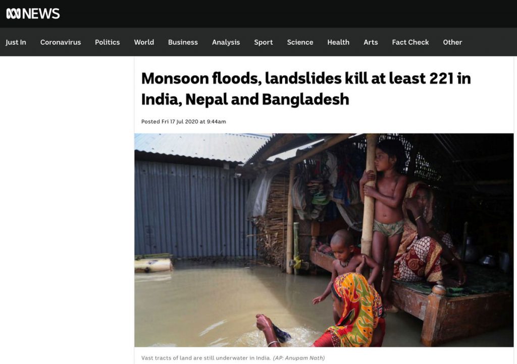
Le piogge monsoniche rappresentano una causa di catastrofiche alluvioni stagionali che, in combinazione con altre pericolosità, come le frane determinano ogni anno numerose vittime. Ad es..negli ultimi 5 anni ci sono state: 60 vittime in India in 2015, circa 500 vittime in India, 57 in Bangladesh e 30 in Nepal nel 2017, oltre 350 vittime in India settentironale nel 2018, circa 200 vittime n India, 27 in Pakistan, e un centinaio in Bangladesh e Nepal inel 2019 e, sino alla metà di luglio 220, le inondazioni monsoniche e le frane avevano già ucciso 221 persone in India, Nepal e Bangladesh (Fig. 4).
A scala locale:
A scala locale, le alluvioni più pericolose per le vite umane avvengono laddove le attività antropiche vengono intraprese senza alcuna pianificazione o controllo. I media ci mostrano costantemente situazioni di acque che fluiscono all’interno dei centri urbani a causa di una impropria ed incontrollata pianificazione urbanistica; ci forniscono continuamente immagini di vaste aree alluvionate a causa dell’incapacità di costruire o mantenere in buono stato le reti idrauliche.
Le alluvioni che affliggono le zone abitate sono spesso dovute ad una mancata manutenzione del sistema di drenaggio, ad un aumento del carico urbanistico e ad una conseguente inofficiosità del reticolo di drenaggio esistente.
Le alluvioni hanno luogo laddove le autorità locali non riescono a rispettare i loro obblighi in termini di: costruzione, manutenzione degli impianti idraulici, pulizia degli alvei, manutenzione del drenaggio in prossimità dei nuclei abitati ecc.
Tab. 4. Lista di alcune delle principali alluvioni avvenute in Europa nel decennio 2010-2020
| Continent Country | River Lake Sea | Year | Type of flood | Causes | Injured territory | Injured population | Victims | Economic losses |
|---|---|---|---|---|---|---|---|---|
| ASIA | ||||||||
| Thailand | South China Sea | 2011 | Combination – Riverine and Costal Floods | Intensive and long Monsoon rainfalls after 3 Hurricanes | 300 000 km2 | 11 Millions p. | 600 p. | 16 Milliards $ |
| Pakistan | Indi | 2010 | Combination – Riverine, Local drainage and high groundwater levels | Monsoon rainfall with Change model | 350 000 km2 | 13,8 Millions p. | 1500 p. | – |
| Philippines | Island | 2011 | Combination of floods | Hard and long Tropic cyclone. Sea tide | – | 300 000 p. | 1000 p. | – |
| Bangladesh | Gang Brahmaputra | 1998 | Combination – Riverine and Costal Floods | Combination – Monsoons and Tropic Cyclone | 100 000 km2 | 70 Millions p. | 1300 p. | – |
| Bangladesh India Nepal | Gang | 1993 | Combination – Riverine Flooding Costal floods | Intensive Monsoons Rainfall | – | 6 Millions p. | 3084 p. | 8,5 Milliards $ |
| China | Yangtze | 1998 | Riverine flood | Intensive rainfall | – | 180 Millions p. | 3656 p. | 31 Milliards $ |
| 1993 | – | – | – | – | – | 11 Milliards $ | ||
| 1995 | – | – | – | – | – | 8 Milliards $ | ||
| 1996 | – | – | – | – | – | 24 Milliards $ | ||
| South East China | 2011 | Combination Riverine floods Several Mud flows | Intensive and very long rainfall | 12 Provinces | 5 Millions p. | 355 p. | – | |
| Japan | Pacific Ocean | 2011 | Coastal Flooding | Tsunami (Earthquake – 8,9 Richter) | 400 km Sea Cost | 5 Millions p. | 15781 p. | – |
| India | Several rivers | 2005 | Rivering flooding | Intensive and long Monsoon Rainfall | – | – | 700 p. | – |
| 2008 | Rivering flooding | Intensive early Monsoon Rainfall | – | 1,2 Millions p. | 150 p. | – | ||
| 2011 | Rivering flooding | Intensive Monsoon Rainfall | – | – | 335 p. | – | ||
| North Korea | Taedong River | 1995 | Rivering flooding | Intensive rainfall | Secondary effect-hunger 300 000 homelles | 2 Millions p. | 800 p. | 15 Milliards $ |
| Indonesia | India Ocean | 2004 | Tsunami wave | Earthquake(9,0-9,3) near to island Sumatra | 15 countries | 1.7 Millions p. | 283 000p. (9000 tourists) 14100 p. – disappear | 16 Milliards $ |
| NORTH AMERICA | ||||||||
| USA | Mississippi | 1993 | Riverine flooding | Intensive rainfall | 9 states | – | 50 p. | 21 Milliards $ |
| Texas | 2001 | Flash flooding, Tropic Storm ”Allison” | Intensive rainfall | – | – | 23 p. | 6 Milliards $ | |
| New Orleans | 2005 | Combination Revering floods | Hurricane “Katrina” | 233 000 km2 | – | 1836 p. | – | |
| West Virginia | 1972 | Dam break of coal mine | – | – | – | 125 p. | – | |
| SOUTH AMERICA | ||||||||
| Argentina Ecuador Bolivia | Several rivers | 2008 | Riverine floods | Intensive and long rainfall – El Nino | – | 150 000 p. | 50 p. | 16 Milliards $ |
| Brasil | Several rivers | 2011 | Riverine flooding | Intensive rainfall | – | 1 | 35 p. | – |
| Venezuela | Rio San Julian | 1999 | Alluvial fan flood | Rainfall storm | – | – | 19 000 p. | – |
| AFRICA | ||||||||
| Mozambique | Limpopo river | 2000 | Riverine Flooding | Torrential rain | 1400 km2 | 800 000 p. | 800 p. | – |
| The Republic of South Africa | Orange river | 2011 | Riverine flooding | El Niño | – | – | 100 p. | – |
| Algeria | – | 2001 | Flash Flood, Alluvial fan flood | Torrential rain | – | – | 827 p. | – |
| AUSTRALIA | Quenensland Floods Fitzroy Burnett Coudamine Ballone Mary | 2010 | Riverine and Costal flooding | Intensive rainfall and strong wind | 800 000 km2 | 200 000 p. | – | – |
| Continent Country | River Lake Sea | Year | Type of flood | Causes | Injured territory | Injured population | Victims | Economic losses |
|---|---|---|---|---|---|---|---|---|
| EUROPE | ||||||||
| Germany Poland Czech |
Oder | 1997 | Riverine | Intense rainfall | – | – | 115 p. | 6 Milliards $ |
| Poland Czech Hungary Slovakia Servia |
Visla Valtava Danube |
2010 | Riverine | Intense rainfall | 80 000 km2 | 3 Millions p. | 9 p. | – |
| Germany | Rein Oder |
2011 | Riverine | Intense rainfall Melt of snow |
– | – | 2 p. | – |
| Germany Poland Czech |
Several Rivers | 2010 | Riverine | Intense rainfall | – | – | 6 p. | – |
| England | Several Rivers | 1998 | Riverine | Intense rainfall | – | – | 5 p. | 3 Milliards $ |
| – | 2009 | Riverine | Intense rainfall Strong Wind |
– | – | 9 p. | – | |
| – | 2011 | Riverine | Intense rainfall | – | – | – | – | |
| France | Several Rivers South France |
2010 | Riverine | Intense rainfall | – | – | 25 p. | – |
| Mallpas-et Dam | 2011 | Riverine | Intense rainfall | – | – | 3 p. | – | |
| Several rivers | 1959 | Dam-break flood | Dam break | – | – | 421 p. | – | |
| Italy | – | 2000 | Riverine | Intense rainfall | – | – | 5 p. | 8,5 Milliards $ |
| Vaiont Dam | 2004 | Riverine | Intense rainfall | – | – | 9 p. | 9,3 Milliards $ | |
| Ebro | 2011 | Riverine | Intense rainfall | – | – | 6 p. | – | |
| 1963 | Devastating flood | Landslide | – | – | 3000 p. | – | ||
| Spain | – | 2010 | Riverine | Intense rainfall | – | – | 3 p. | – |
| – | 2011 | Riverine | Intense rainfall | – | – | 2 p. | – | |
Le conseguenze delle alluvioni si possono stimare attraverso:
- Il numero di vittime;
- L’entità delle perdite sociali ed economiche;
- L’estensione dell’area colpita;
- Il livello di contaminazione ambientale;
- Il grado di distruzione del patrimonio culturale.
Le tipiche conseguenze delle alluvioni possono essere primarie e secondarie.
- Le conseguenze primarie comprendono:
- Danni o distruzione fisica parziale/totale di ponti, macchine, edifici, case, reti di comunicazione, sistemi fognari, sistema stradale e di tutti gli elementi strutturali più importanti;
- Vittime: persone o animali annegati, considerando anche le eventuali epidemie e malattie derivanti;
- Le conseguenze secondarie comprendono:
- Maggiori difficoltà nel reperire risorse idriche: contaminazione dell’acqua in seguito a scarsa dispinibilità di acqua potabile;
- Proliferazione di malattie: condizioni di vita non igieniche. Le malattie si diffondono attraverso l’acqua;
- Maggiori difficoltà nel reperire cibo: il cibo scarseggia. Interi raccolti possono andare distrutti.
- Vegetazione: molte specie possono morire;
- Le conseguenze dell’alluvione possono persistere per lungo tempo;
- Il temporaneo declino del turismo può inasprire la situazione economica, aumento del prezzo del cibo e dei costi della ricostruzione.
Benefici derivanti dalle alluvioni: le alluvioni possono avere numerose conseguenze negative, ma possono anche rendere più fertile il suolo, arricchendolo di numerose sostanze nutrienti. Ad esempio, già dal quinto secolo a.C., l’importanza del fiume Nilo era nota in quanto svolgeva un ruolo economico fondamentale per il popolo egiziano, rendendo fertili terre aride e desertiche. Ogni anno, in estate, il fiume inondava i territori limitrofi; le acque si ritiravano nel letto del fiume in autunno, lasciando uno strato di fango (limo) estremamente fertile sui campi.
Le alluvioni sono un fenomeno naturale che non è possibile evitare. Le cause delle alluvioni sono complesse, ed oltre a quelle naturali (es. intense precipitazioni, fusione della neve, etc..) ne esiste una molto importante, rappresentata dalle attività improprie dell’uomo.
Alcune delle attività antropiche che possono influenzare le cause delle alluvioni sono:
- La riduzione della naturale capacità del suolo di drenare l’acqua, causata dallo sfruttamento del terreno (antropizzazione) e dal disboscamento, che amplifica la velocità di flusso delle acque (Fig. 6);
- Le modifiche della morfologia fluviale;
- L’edificazione di aree soggette alle alluvioni;
- I cambiamenti climatici, principalmente causati dalle attività antropiche, contribuiscono ad accrescere la probabilità di alluvioni e dei relativi effetti.
L’attività antropica rappresenta, in molti casi, la causa delle alluvioni. Le modifiche del suolo e dei corsi d’acqua, la cattiva manutenzione delle strutture idrauliche, la mancanza di pulizia degli alvei, sono tutti elementi che accrescono la probabilità che si verifichino delle alluvioni.

Le conseguenze delle alluvioni, sono fortemente influenzate dai comportamenti umani.
Da un lato, molti comportamenti umani amplificano le conseguenze delle alluvioni; dall’altro, molti altri comportamenti riescono a smorzarle.
Nell’elenco delle azioni che possono amplificare le conseguenze delle alluvioni si possono citare:
- L’espansione dei centri abitati e delle aree produttive nelle zone alluvionabili ed in altre zone a rischio cioè l’urbanizzazione in zone a rischio alluvioni (Fig.. 2.1 c, e Fig. 10).
- La deforestazione e la distruzione della vegetazione amplificano fortemente le conseguenze delle alluvioni.
- La distruzione delle aree d’espansione naturale dei corsi d’acqua.
- La cattiva manutenzione delle reti idrauliche e la mancanza di controlli sulle stesse.
- L’assenza di manutenzione del reticolo di drenaggio in aree urbanizzate.
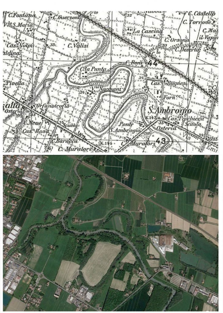
- La modifica del corso dei fiumi Per esempio nel settore di pianura a Nord di Modena la lunghezza dei fiumi Panaro e Secchia è stata ridotta di circa il 12% del percorso in seguito a tagli di meandri realizzati sin dal 19° secolo per ridurre il pericolo di esondazioni. In questo modo i fiumi hanno assunto in lunghi tratti l’aspetto di corsi d’acqua artificiali. Poiché i tagli di meandro non hanno ridotto tale pericolo, sono state costruite delle casse di espansione a Est e a Ovest di Modena (Fig. 9). La morfologia e l’evoluzione del fiumi . Panaro e Secchia sono stati così condizionati direttamente ed indirettamente da interventi antropici degli ultimi due secoli simili a quanto registrato in altri fiumi italiani.
Gli impatti sull’ambiente, causati dai cambiamenti climatici, influenzano direttamente le conseguenze delle alluvioni, poiché ne possono accrescere l’intensità e, in certi casi, possono ostacolarne la previsione.
Nell’elenco delle azioni che possono mitigare le conseguenze delle alluvioni si possono citare:
- Lo sviluppo e l’implementazione delle politiche nazionali di contrasto alle catastrofi;
- La realizzazione di misure di protezione;
- L’organizzazione di sistemi d’allerta per le popolazioni a rischio alluvioni;
- Lo sviluppo e l’implementazione di piani di protezione;
- L’implementazione di strumenti di formazione relativi alla prevenzione del rischio, in aree soggette ad alluvioni;
- Il miglioramento dei sistemi di previsione;
- L’attuazione di un controllo permanente.
Le alluvioni possono essere previste con buon successo grazie alle attuali tecnologie e sistemi di comunicazione e grazie all’enorme database statistico disponibile. Ciò rende possibile prevedere, con anticipo, il momento, la natura e la scala dell’alluvione.
Le condizioni meteorologiche vengono monitorate, a scala globale, attraverso i satelliti meteorologici. Le informazioni relative ad eventi calamitosi vengono gestite dai calcolatori e lo sviluppo della situazione viene previsto sulla base di modelli. Le informazioni che si ottengono, confrontate con quelle provenienti dai servizi idro-meteorologici nazionali, permettono di effettuare una previsione delle alluvioni. Comunque è da tener presente che le previsioni meteo, da cui dipendono le previsioni delle alluvioni, indicano solo la probabilità di precipitazioni in un’area vasta, non la certezza che si verifichino in una località ben determinata
Per quanto riguarda le alluvioni fluviali, più grande è il corso d’acqua, più aumenta la capacità di previsione. L’innalzamento del livello delle acque in un fiume di grandi dimensioni – come il Danubio, Il Volga, il Reno, il Dnepr – è infatti un fenomeno che avviene lentamente, da diverse ore a più giorni. Ciò consente un monitoraggio costante e soprattutto azioni di prevenzione. Al contrario, il livello delle acque di piccoli fiumi o torrenti può crescere molto rapidamente, lasciando tempi di intervento ridotti. In questi casi –non sempre è possibile prevedere eventuali allagamenti, tanto meno quando e dove si verificheranno
L’entità delle alluvioni causate dall’aumento delle portate delle sorgenti può essere prevista anche più di un mese prima del loro verificarsi, analizzando lo spessore del manto nevoso, l’umidità del suolo, la temperatura ed altri parametri.
Le alluvioni causate da forti venti di tempesta possono essere previste da 1-2 ore a 1-2 giorni prima del loro verificarsi.
La previsione di un’alluvione causata da un maremoto si basa sulla tempestiva valutazione dell’ubicazione dell’epicentro e della magnitudo del terremoto, da cui è poi possibile, attraverso l’utilizzo di un modello, prevederne l’arrivo ed allertare le popolazioni a rischio.
Quando si opera una previsione, occorre considerare, per ogni area, il regime naturale dei corsi d’acqua, influenzato dalla presenza di argini, briglie, chiuse, canali ecc.
Le moderne tecnologie permettono di prevedere in modo corretto le condizioni meteorologiche e, insieme ai risultati provenienti dai servizi idro-meteorologici nazionali, permettono di prevedere l’origine e lo sviluppo delle alluvioni. Queste possibilità permettono di allontanare la sorpresa ed il panico e di pianificare in modo più efficiente attività di protezione civile per le popolazioni e, laddove necessario, attività di salvataggio.

Esistono diversi modi di prevenire le alluvioni che, se realizzati in modo integrato, possono ridurne Il loro accadimento.
La prevenzione delle alluvioni può essere implementata alle seguenti scale:
- Globale – attraverso la salvaguardia dell’ambiente, il contrasto ai cambiamenti climatici e attraverso lo sviluppo di sistemi di previsione;
- Regionale – attraverso la creazione di sistemi di prevenzione, di previsione e di allerta, come quello implementato dopo lo tsunami nell’Oceano Indiano nel dicembre 2004. Lo tsunami fu innescato da un terremoto sottomarino (M = 9.1) che ha colpito l’isola indonesiana di Sumatra uccidendo almeno 225.000 persone in una dozzina di paesi;
- Nazionale – attraverso la creazione e l’implementazione di una politica nazionale per combattere le catastrofi naturali e, in particolare, le alluvioni;
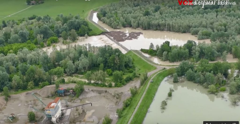
Locale – attraverso l’implementazione di un complesso di misure – sviluppo e mantenimento dei piani di protezione, controllo ed attività che possano contribuire alla previsione delle alluvioni ed alla riduzione delle loro conseguenze, costruzione e manutenzione di strutture idrauliche ecc.; per quanto riguarda le strutture idrauliche, ad esempio, nell’Appennino settentrionale e centrale (Italia), da alcuni decenni sono stati costruiti dispositivi di regolazione del flusso d’acqua in aree adiacenti ai corsi di alcuni fiumi (Parma, Enza, Secchia, Panaro, Arno, Tevere e altri …) al fine di controllare il rischio idrologico delle piene fluviali. Tali strutture (chiamate “Casse di espansione” o “Casse di laminazione”) sono costituite principalmente da una diga di regolazione realizzata attraverso l’alveo e da un bacino di stoccaggio delimitato da argini. La loro funzione più importante è quella di ridurre il picco di piena, cioè intervengono su scala limitata (Fig. 9).
- Misure per la protezione personale dovrebbero includere: educazione scolastica, costruzione di una propria consapevolezza rispetto al rischio alluvioni nei luoghi in cui viviamo o soggiorniamo, conoscenza delle azioni da intraprendere sia prima che dopo un’alluvione, possesso di capacità minime di pronto soccorso ecc.
E’ possibile mitigare gli effetti negativi delle alluvioni, specialmente quelle che mettono a rischio la vita delle persone, l’ambiente, il patrimonio culturale, le attività economiche e le infrastrutture, attraverso l’implementazione di politiche coerenti e ben ponderate, a livello mondiale, regionale, nazionale e locale.
La lotta alle alluvioni comprende sia attività implementate in accordo a piani di lungo periodo, sia attività a breve termine.
Esempi di attività di lungo periodo possono essere la creazione di diverse strutture di protezione e la loro annuale manutenzione, oppure la creazione ed il mantenimento di diversi piani di protezione.
Le attività a breve termine vengono pianificate annualmente e sono implementate in caso di alluvione. Scorte di: materiali idrorepellenti, sacchi di sabbia, pompe, generatori elettrici. Organizzazione costruita sulla base dei piani esistenti. Controllo dei sistemi di monitoraggio ed allerta alluvioni. La pulizia del sistema di drenaggio e degli alvei fluviali è estremamente importante ed è diretta responsabilità delle autorità locali.
L’efficienza del contrasto alle alluvioni non dipende solo dalle specifiche condizioni climatiche e dal regime dei corsi d’acqua di una certa zona, ma anche dall’ubicazione dei centri abitati e dalla disponibilità di strutture idrauliche efficaci nel regolare il deflusso delle acque (vedi Fig. 9). Comunque gli effetti di un’alluvione si riducono soprattutto con provvedimenti che impediscono o limitano l’espansione urbanistica nelle aree allagabili così come le aree golenali (.(vedi Fig. 10).
L’esperienza dimostra come sia assolutamente possibile evitare conseguenze catastrofiche quando le previsioni sono state fatte in modo corretto e con adeguato anticipo e quando le rispettive attività vengono implementate tenendo in considerazione le condizioni locali. I fattori che contribuiscono maggiormente a ridurre le conseguenze di un’alluvione sono l’organizzazione di un sistema di allerta, l’addestramento ad assumere comportamenti corretti ed il primo soccorso.
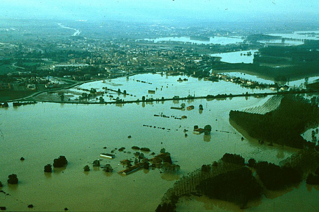
Per reagire nel modo corretto e per evitare il panico in caso di alluvione, è necessario essere già preparati, in modo che tutti sappiano cosa fare.
Per prima cosa dobbiamo sapere se il luogo dove abitiamo è stato interessato da alluvioni e quali ne sono state le cause.
Secondo – è molto importante procurarsi un’assicurazione contro le alluvioni se si vive in un’area a rischio.
Terzo – si deve preparare un piano di protezione individuale contro le alluvioni.
Le fasi per la protezione personale includono:
- Prima dell’alluvione e durante l’allerta:
- Conoscenza dei piani di protezione da alluvioni;
- Le autorità locali attivano alcune procedure del piano di protezione: informano la popolazione in pericolo, predispongono il monitoraggio delle sezioni fluviali in pericolo, avvertono la popolazione con segnali d’allarme ecc.;
- Valuta se mettere al sicuro l’automobile o altri beni: può essere pericoloso.
- Se devi evacuare, valuta prima il percorso ed evita le zone allagabili.
- Al segnale di evacuazione non avere esitazioni, poiché il ritardo delle azioni di evacuazione potrebbe mettervi in pericolo. Abbandonare di propria iniziativa la zona colpita può essere molto pericoloso;
- Se si possiedono sostanze velenose o pericolose, chiedere a specialisti cosa fare con esse. Se si ha tempo, chiudere la pittura, i pesticidi, i fertilizzanti e altre sostanze pericolose in scatole di plastica e rimuoverle dal pavimento;
- Trasportare gli strumenti elettrici al piano superiore.
- Durante l’alluvione:
- Prestare attenzione alle comunicazioni ed alle istruzioni trasmesse da radio e TV;
- Cercare di mantenere la calma ed evitare situazioni di panico;
- Non appena l’alluvione ha inizio, o se si crede che un’alluvione stia approssimandosi alla vostra abitazione (osservando il livello delle acque, la presenza di nuvole temporalesche, piogge intense o la vicinanza della vostra casa a sorgenti), non esitate e spostatevi immediatamente verso piani rialzati, anche se non si sono ricevute indicazioni in tal senso: questa è la vostra personale decisione;
- Occorre sapere che le valli ove scorrono acque sorgentizie (anche se asciutte), i canyon, i fossi di ruscellamento ed i canali di drenaggio sono i luoghi più pericolosi in caso di repentine alluvioni;
- Non percorrere sottopassi stradali
- Nel caso tu sia in vacanza dovresti conoscere le istruzioni importanti e seguire le indicazioni delle autorità locali. L’esperienza dimostra che le maggiori perdite sono generalmente subite dai turisti
- Se ti trovi nella zona alluvionata:
- Spostati al piano superiore e non esitare a salire sul tetto, se necessario;
- Se ti trovi in un bosco, sali su di un albero;
- Se ti trovi in acqua, cerca di nuotare verso una zona asciutta;
- Se ti trovi in una forte corrente d’acqua, non cercare di nuotare contro corrente o sulla corrente, ma nuota mantenendo un certo angolo rispetto alla sponda/costa.
- Se ti è stato indicato di evacuare, procedi nel seguente modo:
- Se hai tempo, trasporta le cose indispensabili al piano superiore;
- Disconnetti la rete elettrica, del gas e dell’acqua (non toccare elementi elettrici se sei bagnato o se sei immerso in acqua);
- Se hai tempo, inchioda un’asse alla porta ed alle finestre.
- Non attraversare nessun flusso d’acqua, ma se devi, controlla la profondità dell’acqua davanti a te con un bastone;
- Non guidare attraverso zone allagate e se il livello dell’acqua intorno all’automobile si alza, abbandona immediatamente l’automobile e spostati verso piani rialzati.
- Se sei costretto a rimanere nella tua abitazione durante l’alluvione:
- Presta costante attenzione alle informazioni di radio e TV;
- Rimani ad un piano superiore, se possibile;
- Metti tutti i documenti, il denaro, le cose di valore e le medicine importanti in una borsa adatta;
- Dopo l’alluvione:
- Dopo l’evacuazione puoi tornare alla tua abitazione solo se è permesso dalle autorità locali;
- Non transitare lungo strade allagate: potrebbero esserci voragini, buche, tombini aperti o cavi elettrici tranciati. Inoltre, l’acqua potrebbe essere inquinata da carburanti o altre sostanze.
- Fai attenzione anche alle zone dove l’acqua si è ritirata: il fondo stradale potrebbe essere indebolito e cedere.
- Apri le porte e le finestre e crea ventilazione nella casa;
- Non riattivare la rete elettrica prima che questa venga controllata da uno specialista;
- Controlla la rete del gas;
- Non utilizzare acqua e cibo senza prima averli controllati.
Nell’ambito del progetto italiano IONONRISCHIO è stata predisposta una scheda che contiene informazioni utili sui comportamenti da adottare durante l’allerta, durante l’alluvione e dopo l’alluvione. La scheda può essere scaricata al link
Le carte possono essere: geografiche, economiche e fisiche, includendo anche diverse carte meteorologiche: per le piogge, per il deflusso dei fiumi, per i venti. Possono essere a scale diverse, a seconda del loro utilizzo. Le carte delle alluvioni devono aiutare a prevedere quali aree possono essere colpite ed a pianificare le azioni di difesa. E’ preferibile utilizzare carte topografiche o carte con Modello Digitale del Terreno, giacché è molto importante individuare le aree topograficamente rialzate qualora si verifichi un’alluvione e si debbano predisporre le misure di difesa. Le carte digitali, combinate all’uso del GPS, sono da preferirsi.
Le carte predisposte per la scala di bacino sono le seguenti:
Carte delle aree potenzialmente interessate da alluvioni: Carte di pericolosità alluvionale
- Carte delle aree ove è presente un determinato rischio da alluvione: Carte di rischio alluvionale.
- Le mappe della pericolosità alluvionale, a piccola e/o a larga scala, mostrano l’estensione e i livelli d’acqua previsti in caso di allagamento secondo tre scenari: uno scenario a bassa probabilità o eventi estremi, uno scenario a media probabilità (con un periodo di ritorno di 100 anni) e uno scenario ad alta probabilità. C
- Come esempio di cartografia di pericolosità alluvionale in Italia, l’Autorità di Bacino del Fiume Po (AIPO) è da tempo attiva per l’identificazione e la mappatura delle aree a pericolo di alluvione dell’intero bacino idrografico del fiume Po. È stata sostanzialmente applicata una metodologia semplificata basata sul perimetro delle alluvioni storiche individuando così tre distinti scenari di alluvione: scenario a bassa probabilità (periodo di ritorno 500 anni), scenario a media probabilità (periodo di ritorno 100-200 anni), scenario ad alta probabilità. Vedere la Fig. 12.1 e la Fig. 12.2.
- Le mappe del rischio di alluvione vengono preparate per le aree allagate in questi scenari che mostrano la popolazione, le attività economiche e l’ambiente a potenziale rischio di inondazioni e altre informazioni che possono essere utili da includere, ad esempio, altre fonti di inquinamento.
Tali mappe sono usate per determinare le regioni che possono essere interessate da inondazioni e i danni che ne possono derivare. Le misure per proteggere la popolazione e le attività a lungo termine per mitigare le conseguenze della inondazioni sono pianificate sulal base di queste mappe.
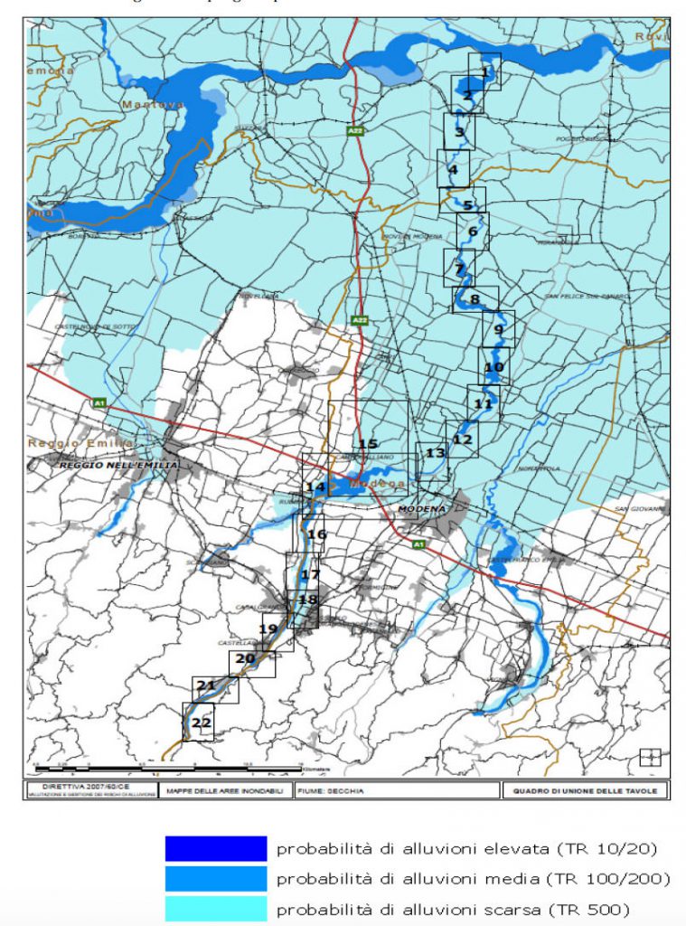
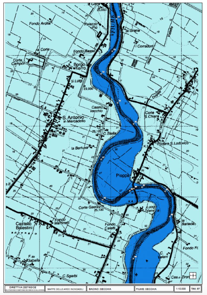
The maps of the regions under threat of a flooding cover the geographical locations that can be flooded and reflect:
- floods that are less likely to occur or cases of unforeseen events;
- floods with medium probability to occur /probability of second occurrence – more than 100 years /;
- floods with high probability to occur.
On the bases of prediction on these maps, several activities with long and short term character aiming to prevent or to reduce flood consequences are planned and implemented and planes for defense are elaborated.
The maps of the regions under risk of flood show the possible negative consequences of the flood and reflect:
- a project number of population that could be possibly affected;
- type of economic activity in the region that will be possibly affected;
- installations for complex prevention and control of contamination, that may cause additional contamination due to flood-caused technical failures.
On the bases of prediction on these maps the activities for protection of the damaged populayion on regional and local level, the long and short term activities are planned. An individual plan for action at flood danger for you and your family can be prepared on the bases of these maps.
You are entitled to familiarize yourself with the maps and to receive the information you require concerning danger of flood, and if a proper organization is in place, to receive such maps or excerpts thereof.
Even more – it is the obligation of every citizen to be aware of what dangers are possible in his living location. It is especially important to familiarize yourself with the map and to check whether the home you live in, the school you study in, or your work place are located in zones in danger of flood. On the basis of that you can request information for the existing protection plan and the steps you need to undertake in case of danger, during, and after a flood.
The maps are prepared, maintained and kept by the respective institutions in a country – normally these would be the Basin directorates and Civil Protection Service.
From the map you can learn about the obligation of the local authorities for prevention from flood at sudden danger from flood.
From the maps you can learn about the obligation of the local authorities for prevention from flood risk and to insist to be implemented.
From the maps on Internet you can get orientation about the existing rivers, springs, dams and other hydro technical facilities which can cause flood.
At school you can create you own map of the danger zones from flooding for the place where you live, the way to school and at school to predict and discuss what you have to do in case of flood if you are any of these places. Before going abroad with your parents on holiday you can learn from the Internet map about the existing danger from some types of floods.
We have prepared a map of the floods all over the world on the bases of “Google Maps”.
You can look at the map and decide whether there is a thread from flood for a place you wish. You may try to make a prediction about the areas threatened by flood. The icons of Google have been used. You can add to any place threatened by flood or hurt by flood: pictures, texts, drawings, videos etc. This map can connect with GPS navigator and we can exactly to the place we want – where we live, the place we will go on holiday with our parents.
View Floods Prevention – ECRP (BG) in a larger map