Mentre una comunità costiera può non subire alcun danno dalle onde di maremoto, una comunità vicina può invece essere gravemente colpita e devastata.
I modelli numerici sviluppati per prevedere il potenziale di inondazione da maremoto – la penetrazione nell’entroterra delle onde a partire dalla costa – possono identificare le aree che con maggior probabilità verranno inondate in occasione di maremoto (favorendo la costruzione di carte di pericolosità/vulnerabilità), nonché quali percorsi possono essere utilizzati dalle persone per raggiungere agevolmente zone sicure (favorendo la costruzione di carte di evacuazione).
Le carte delle zone inondabili da maremoto – aree potenzialmente raggiungibili dalle grandi onde – possono essere utilizzate dai pianificatori e dai politici per istituire zone d’evacuazione e percorsi per raggiungere zone sicure.
A questo scopo, le osservazioni del limite raggiunto dalle acque e delle zone inondate in occasione di maremoti precedenti divengono essenziali per verificare la validità delle mappe prodotte attraverso l’utilizzo dei modelli numerici.
One of the key tools for tsunami mitigation is the study and production of hazard maps of local coastal areas to ascertain how vulnerable they are to tsunamis – this can vary greatly along shorelines depending on the intensity of the waves, undersea features and the topographical lay of the land.
Hazard maps require knowledge of the historical tsunami record in order to estimate the probability that a tsunami will occur in the future. An integral part of emergency preparedness is understanding the tsunami hazard or threat. Since earthquakes are the most probable source, seismic hazard maps are needed to identify the potential earthquake source zones. In the case of tsunamis, this also includes trying to predict the potential height of waves.
In high-risk areas where the maximum potential source of a tsunami is known – for example if there is an active earthquake subduction zone offshore – tsunami generation, propagation and run-up can be mathematically modelled and wave heights estimated. Also, historical records of previous tsunamis charting earthquake magnitudes, and wave heights and run-up and inundation patterns, can be used to support tsunami hazard predictions.
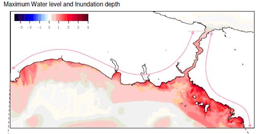
One such study as outlined previously was performed for Istanbul, Turkey (Figure 1). Comprehensive tsunami simulations were based on 49 different scenarios considering not only active faults but also submarine landslide induced tsunamis by using OIC, a widely accepted, scientifically verified tsunami simulation code TUNAMI N2. The animations of the selected scenarios have been prepared by METU, The Department of Civil Engineering, Ocean Engineering Research Center using the tsunami simulation and visualization code NAMI DANCE, which has been developed for tsunami numerical modeling and simulations by Profs..Nobuo Shuto and Fumihiko Imamura in Tohoku University Japan. TUNAMI N2 determines the tsunami source characteristics from earthquake rupture characteristics. It computes all necessary parameters of tsunami behavior in shallow water and in the inundation zone allowing for a better understanding of the effect of tsunamis according to bathymetric and topographical conditions. For further information, http://yalciner.ce.metu.edu.tr/marmara/index_eng.htm
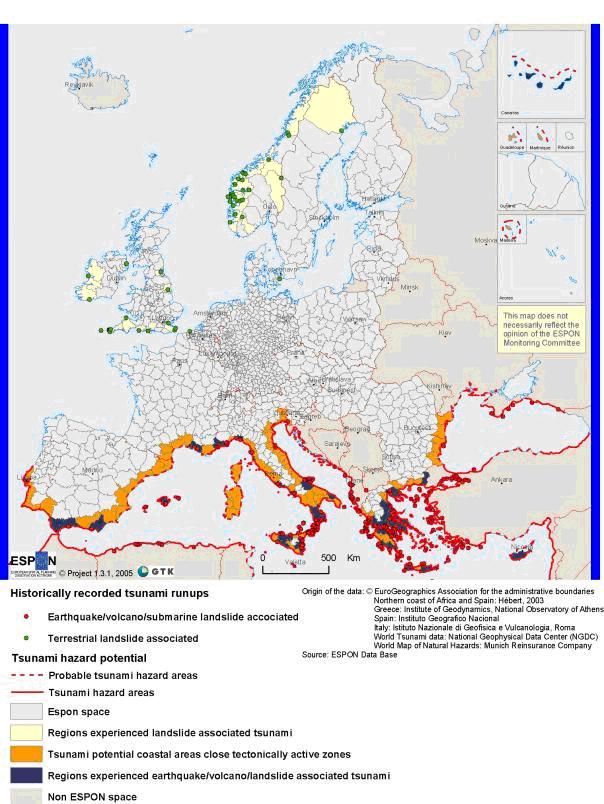
Tectonically induced tsunamis occur in Europe mainly in the Mediterranean and the Black Sea. There are several geological and historical records of tsunamis (see above). The most endangered zones lie in close vicinity to the main volcanoes or along seismically active zones. Tsunamis caused by (submarine) landslides have mainly occurred in Norway, but also in some other areas in Europe (Figure 1). Often it is difficult to distinguish if an earthquake caused a tsunami or if an earthquake triggered a (submarine) landslide that then caused a tsunami. In general it can be concluded that tsunamis are possible along all shorelines that lie in tectonically active zones and/or in areas where (submarine) landslides are possible. Even though no devastating tsunamis have occurred in Europe in the last 100 years, the potential hazard is still high. (http://www.gsf.fi/projects/espon/Tsunamis.htm)